Toggle navigation
Search
Image Search
Keyword Search
New Images
Contact
Filter
Rights Managed (RM)
Royalty Free (RF)
Model Release
Property Release
Horizontal
Vertical
Square
Panorama
Search mode
Normal
Split
Per page
15
25
50
Layout
Filter
Download comp image
Please request a quote
Filename
333D8SDZ
License
Rights Managed (RM)
Licensing terms
Dimensions
4252 x 2870 pixels
Copyright
Arterra / Philippe Clément
more images of Arterra / Philippe Clément
Caption
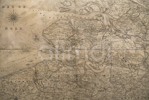
1831 map Carte des Frontières, showing boundaries between The Netherlands and Belgium, Etablissement géographique de Bruxelles / Philippe Vandermaelen
Model Release
No
Property Release
No
Information
Please request a quote
You want to get a quote? Please send us a request and let us know the details of the intended use please.
1831
19th
20
antique
belgian
belgium
border
borders
boundaries
boundary
bruxelles
carte
cartographer
cartography
century
cities
de
des
dutch
etablissement
frontières
geographer
géographique
geography
historic
historical
januari
map
maps
netherlands
nineteenth
old
philippe
science
sciences
the
travel
vandermaelen
vintage
Search selected keywords
Need some help?
info@alimdi.net
Home
About Us
Prices
Licenses
Photographers
Image Search
Keyword Search
Imprint
Privacy Policy
Terms of Use
Cookies
Contact
GTC
© 2006 - 2024 - All rights reserved - alimdi.net
Deutsch
|